Sussex Inlet is located at 35 degrees 11 minutes South and 150 degrees 36 minutes East. This detailed information is for airline pilots and sailors to enable them to locate us on the world maps.
There is room to land a seaplane on the Inlet as has been done in the past.
For us mortals, turn off the Princes Highway 205 km south of Sydney or 867 km north of Melbourne and travel 13 km to the east, all on sealed roads.
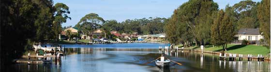
Situated 35km south of Nowra Sussex Inlet is popular for water sports, being on the small river, called ‘The Inlet’ which connects St Georges Basin with the ocean.
Travel time from Sydney is approximately 3 hours.
The road from the Princes Highway passes through a State forest and then past many 5 to 10 acres house lots, some of which back onto the Conjola State Forest.
Average summer temperatures are Maximum – 24C. Minimum 17C
Average winter temperatures are Maximum – 18C. Minimum 8C
There is a population of some 4,000 permanent residents in Sussex Inlet and adjoining areas of Berrara, Cudmirrah and Swan Haven including farmlets en route from the Highway to the township, this figure is based on the 2001 census and grows dramatically during the holiday periods.
A feature of the town is the housing development situated on a tidal canal system. The canal system has in fact caused the business area of Sussex Inlet to now be located on an island. It is known as the “Island Township”.
There is a life saving club at the surf beach. Other activities available include lawn bowling, fishing, sailing, golf, bingo, water skiing and swimming in sheltered waters. There are several boat hire businesses with small motor boats for hire plus house-boat hire is also available.
There are a large variety of wild birds in the area and in the area known as Badgee, kangaroos can be seen feeding on the lawns of the houses at morning and evening.
Traveling distances from major centres
- Sydney – 198 km
- Mittagong – 111km
- Nowra – 43km
- Ulladulla – 40km
- Batemans Bay – 92km
- Canberra – 237km – via Batemans Bay
- Canberra – 200km – via Neriga, Mainroad 92
- The History of Sussex InletAlthough Captain Cook had named various landmarks along the south
coast (Mt Pigeon House, Cape St George ) on his discovery voyage of
Australia, it was not until 1882 that further exploration opened up more
land for settlement along the Southern coastline.In January of that year Alexander Berry, Hamilton Hume and Lieutenant
Johnston, R.N. (having already sailed up the Shoalhaven River as far as
Burrier) sailed southward on H.M.Cutter Snapper.After pausing in Jervis Bay for fresh water, they continued south until, crossing the bar at the entrance to Sussex Haven, they followed the river to St George’s Basin. There is, unfortunately, no written report of this
five mile journey; however, a chart was drawn using the surveyor’s(Edwardsons) notes– showing the observations of the forest grassy flats, water depths, sheltered bays etc. along the banks of the inlet.Another Surveyor, Thomas Florence, travelled overland from Jervis Bay to St George’s Basin in 1827, and having noted the native name (Bherwerre) for the Basin also mapped out the narrow inlet(‘Sussex Haven’) as well as the Swan Lake and ‘Canal Lagoon'(Berrara) entrances.
Although at this stage Wreck Bay had still to be named, it had begun taking its toll from as early as 1805. It wasn’t until the Barque Juniper went down there in September 1850 that its present name was given. Since that time a dozen ships have been lost in the Bay, one of the better known being the Walter Hood in 1870.
The Walter Hood carrying Italian tiles for the roof of St Mary’s Cathedral, Sydney, was buffeted by continuous gales for two days,
sending her shorward off Red Head. Eventually she struck a rock formation 200 yards or sofrom shore where she perched helpless in the rough seas. Fortunately the ship did not break up immediately, though the surviving passengers suffered a terrible ordeal waiting rescue. It was not until the following Saturday that help, in the form of the Illalong arrived to pluck the survivors from the wreck, after a tricky rescue by the lifeboats. She was beached at Nerrindillah Creek about two miles north of Red Head.A sandstone monument, erected at a cost of three hundred pounds – raised by public subscription – stands just north of Red Head. It is supposedly a mass grave for thirteen of the men drowned from the Walter Hood .
Two Glanville brothers came to the Shoalhaven District from Cornwall Richard in 1830 to Bamarang and his brother John to Wagamia in 1844. John is believed to have been related to Daniel Glanville (possibly another brother, but unfortunately no records available) who in 1849 married Eliza Hughes and lived in the Wagamia area until 1865. With his eight children George, Emma, Thomas, Alice, Charlotte, Eliza, Lucy and Elizabeth he then moved to land purchased by him at Berrara. This was the site of the old staging post, en route from Shoalhaven to Ulladulla and Daniel put up some sort of temporary dwellings as well as stables and a blacksmith’s shop, probably for the use of travellers, and started clearing the surrounding land for farming.
Sussex Inlet saw only passing horsemen and wagons as they came to the entrance to ford the river across to Berrara and southward. The surrounding bush at that time (and as far as Jerrawangala) was alive with koalas, wallabies and dingoes, but no kangaroos. Wild horses roamed the vicinity, probably escaped from properties further north, and it was different in character from today, when kangaroos roam the area but the koala and dingoes havedisappeared.
Acknowledgment: – The above details have been extracted from the
“A Story of Sussex Inlet” booklet written by Elva Kemp and Carole
Coshaw. It is on sale at the RSL Club and the Newsagent.If you If you know more – Please let us knowemail address- admin@sussexinlet.info
Acknowledgment: – The following details have been extracted from “The Inletter, Bicentenary Edition” which was produced in January 1988 by the Sussex Inlet Foundation for Community Development Inc. Cnr Jacobs Drive and Nielson Rd, Sussex Inlet.
The first Post Office opened in Sussex Inlet 1st November 1920. The population at that time was between 50 and 60 plus 30 to 40 professional fishermen camped at the of the Inlet. During the summer months, at any one time, about 150 visitors were accommodated in the boarding houses.
The first telephone was connected to a subscriber at Sussex Inlet on the 14th April 1906. In 1939 a telephone exchange opened at Sussex Inlet with only 9 subscribers. The automatic exchange was cutover on the 13th August 1970 with 186 telephones connected to the service.
In January 1950 Jack and Clive Curtis set up their tent on what was to become the 8th fairway of the golf course. After 12 months three fairways and greens were complete. It was December 1956 before the course was opened with all nine holes and the club house complete. The Sussex Inlet Golf Club was formed in 1953 with 8 members.
The Sussex Inlet Bowling Club was commenced in the mid 50’s The new club house was opened on the 30th October 1966.
The Royal Volunteer Coastal Patrol commenced in Sussex Inlet in the early 1970’s with a radio watch being maintained. In 1983 the first patrol boat was purchased, previously they had operated with privately owned vessels.
In 1986 a jet propelled vessel was purchased and subsequently updated in 2005.In 1950 James Cater commenced work on the canal system. The first part of the work was on the northern side of Jacobs Drive, and then a further canal was developed along Cater Crescent. Lucas & Tait then brought the canal system to its present stage of development.