The local area offers many well known walks with many spectacular views.
Shoalhaven Bushwalkers Inc. is a bushwalking club based in the beautiful Shoalhaven region on the south coast of New South Wales which is centred in Nowra – approximately 160 kms south of Sydney.
For more information about the Shoalhaven Bushwalkers Club visite their website here. Shaolhaven Bushwalkers Website
BEN’S WALK – NOWRA
This walking track retraces part of a walk which was established during the depression years by Ben Walsh. It has been planned and constructed by the Crown Lands Office in conjunction with the Shoalhaven City Council and other interested persons and organisations.
The track commences at the Shoalhaven Showground. Superb views of the river, golf course and mountain scenery can be enjoyed from vantage points along the way. From Hanging Rock, the track descends the cliff face and follows the Nowra Creek beneath huge sandstone boulders and eroded shelves. A suspension bridge has been constructed to provide a loop walk on both sides of the creek and to give access to Depot Farm Recreation Reserve and picnic area.If you wish, you may continue on to the upper tidal limit of Nowra Creek, returning via the swimming holes at Platform Rock and Big Rock and thence back towards the suspension bridge along the cliff line and on to Hanging Rock. The track then rejoins the main route, following Scenic Drive until it reaches the track head at the Shoalhaven River Bridge.
The complete track provides a leisurely return walk of about 5.5kms taking about 2 hours. Enjoy your walk!
BOMADERRY CREEK WALKING TRACK
This scenic walking track is one of a network of tracks established by the Crown Lands Office throughout New South Wales.
Access to the principal track head is via Narang Road in Bomaderry, there are a small number of parking spaces at the track head but extra spaces are available at the Bomaderry Tennis Courts 50 metres away.
The route of the track follows Bomaderry Creek which has carved a course through sandstone forming impressive cliffs, rock walls, overhangs and caves. Commencing at the Weir/Narang Road track head there is a choice of walks available;
•A 5.5km return walk along the eastern and western tracks taking about 3 hours.
•A 1.4km return walk along the western track to Rock Crossing, returning to the track head via Mossy Gully, taking about 1 hour.
The walk is mostly flat with a few steps and one vertical ladder approximately 1.5 metres high to provide access over a large rock formation.
A detailed map of the walk, picnic and barbeque facilities are available at the Weir track head. The water in Bomaderry Creek is not suitable for drinking so carry your own drinking water.
THE GROTTO – NORTH NOWRA
This is a beautiful walk with steep entrances and exits zigzagging down 45 metres from the cliff tops to the banks of the Shoalhaven River.
Drive from Nowra via Illaroo Road, McMahons Road, Hanson’s Road, Gunyuma Crescent and Yurunga Drive. Just past Kareela Crescent around the bend you will find a spot to park 3 or 4 cars off the road. There is a Danger sign there warning about the cliff tops in the vicinity.You will see 2 signs, to the Lookout and The Grotto. Firstly, go to the lookout and see a magnificent view of the river, the golf course and Nowra district through the tree-tops. Now take the right track to The Grotto. Another track to the right is where you will come out at the finish of the walk. Keep left and zigzag down a steep set of rocky steps almost to the river level. Go right, as the way to the left goes to a gate for the Nowra Golf Course. Take great care with children on the walk down.
Along the usually mown grass at the bottom is the site of an old farm built in the 1920?s, and orchard, some of the trees from the orchard are still there today. This is a great place for a picnic. Continue a short distance till you find the other set of zigzag steps leading up to a 7 or 8 minute climb to the top.
PIONEER FARM MUSEUM – KANGAROO VALLEY
The museum is on the northern side of the Kangaroo River at Hampden Bridge. Drive into the parking area and pay a small entry fee at the office. There are two circular walks which can be done separately or together. For the full walk, after crossing the swing bridge, turn left and take the Red Walk. Soon the river will appear far below (you will have already passed a track which leads down to the water’s edge). Cross the little log bridge and follow the red tree markers. Keep to the left when you come to a junction (you will exit via this path later on). Climb down into Nelsons Creek, cross it and walk upstream to Toms Pool. While there, take the 5 minute circular walk around the Moss Gardens and back to the pool. Then climb up and out of the creek and continue along the top trail back to the junction previously mentioned. After crossing back over the log bridge, turn left and follow the red and white markers in a clockwise direction back to the museum. You now have the opportunity to explore the museum together with its picnic facilities, shelter sheds, shop outlet, bbqs and toilets.
JERVIS BAY NATIONAL PARK – GREENFIELDS BEACH
The area now known as Greenfields Beach remained untouched until 1942 when Colin Greenfield leased 12 acres behind the beach. The pine trees that border the picnic area once surrounded the old property. A committed naturalist, Greenfield lived alone at his much loved “Spud Cove” until the early 70?s when, due to failing health, he swapped his property for two flats in Huskisson owned by Max Vost. The Vost family enjoyed their years at this idyllic location until the land was sold to the Department of Planning in 1977 and set aside for public recreation.
Two lined tracks from Greenfields Beach provide a 1 – 2 hour walk along the coast and into the forest. The main track, White Sands Walk, also extends north (outside the National Park) to Blenheim Beach and Plantation Point. White Sands Walk (2km return) begins at the boardwalk, crosses the creek and follows the coast. Interpretive signs at the start and along the track highlight the importance of the bay. If you wish to continue to Hyams Beach, go down the steps at the end of White Sands Walk, cross Duck Creek and walk through the forest behind Hyams Beach to Aster Street. From here you may choose to return via Chinamans Beach – linking up with the track at Duck Creek.
WIRREECOO WALKING TRAIL & MANGROVE BOARDWALK – HUSKISSON
This walking trail is accessible from the Crown Reserve adjacent to the Lady Denman Heritage Complex. There are two parts to the walk, the Wirreecoo Walking trail can take up to 1 hour and the Mangrove Boardwalk takes about 30 minutes.
Three broad ecological groups of vegetation can be experienced on this walking trail.
•Estuarine Wetlands
•(Blackbutt) Coastal Dune Forest
•Dry Schlerophyll forest, or spotted gum forest
The Lady Denman Heritage Complex houses the only wooden Lady Class Ferry left in NSW and was built in Huskisson. The museum is open daily from 10am – 4pm, however, the walks are open to the public at all times.
BOODEREE NATIONAL PARK – JERVIS BAY
Beautiful Booderee National Park is located on the southern peninsular of Jervis Bay. Booderee is an Aboriginal word from the local Dhurga language meaning ‘bay of plenty’ or ‘plenty of fish’.
The National Park and Botanic Garden were handed back to the Wreck Bay Aboriginal Community in 1995.
The Booderee National Park is full of spectacular scenery and a huge array of animal and bird life may be spotted on the many walking trails.
For further information contact:
Booderee Visitor Centre
(02) 4443 0977
www.booderee.gov.au
ABRAHAMS BOSOM RESERVE – CURRARONG
Ever since the first sailing ships and later, steam ships, began to travel the east coast of Australia, their captains have referred to Beecroft Headland, north of Jervis Bay, as Abrahams Bosom. This ancient description of paradise comes from the Old Testament which says that the children of God found shelter, safety and security in the Bosom of Abraham until the coming of their Messiah. In a similar way, Beecroft Headland afforded shelter to vessels plying the coast in turbulent weather. Unfortunately, the SS Merimbula ran aground on this headland one stormy night in 1928. At first light all the passengers and crew were taken to safety on Abrahams Bosom Beach.
Two walks have been established within Beecroft Headland on the Crown Reserve known as Abrahams Bosom Reserve. Wreck Walk: A 2.5km return walk which takes a leisurely one hour on an easy gradient and takes in the site of the wreck of the SS Merimbula which ran aground at 1.00am on 27th March, 1928. Coomies Walk: This includes the Wreck Walk and is a 9km, hillier walk and takes about 3 hours. A feature of this walk is the panoramic view from the Trig Station. Both walks feature coastal seascape scenery of beaches, estuaries, ocean, rock formations, massive sandstone cliffs and headlands.
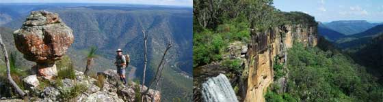
PIGEON HOUSE WALK – PIGEONHOUSEMOUNTAIN – DIDTHUL
The climb to the summit of Pigeon House Mountain is becoming an increasingly popular activity with over 8,000 people making the effort each year. From the top of the mountain there are magnificent panoramic views of the rugged cliffs and gorges carved by the Clyde River and its tributaries. Dominating the view to the north-west are two elongated plateaux of Byangee Walls and The Castle. On a good day, coastline stretching from Point Perpendicular in the north to Mount Dromaderry in the south can be seen, making the walk a most rewarding experience.
How to Get There: There are two roads that lead off the Princes Highway to the Pigeon House Mountain walking track. 1. At Milton, turn into Croobyar Road 2. Approximately 3kms south of Burrill Lake into the Wheelbarrow Road. Travel to the car park and picnic area at the start of the track (approx. 27kms). The walk to the top of Pigeon House Mountain and return takes about 4 hours. This walk can be divided into four stages:
Stage 1: A steep climb of 800m from the car park to the first cliff line and the National Park boundary. The track follows a steep spur through a forest of Black Ash with an open understorey. The rock types of this first section are metamorphosed Ordovician sediments that are about 490 million years old (give or take a year). The first sandstone cliff line is early Permian, which is about 250 million years old. Stage 2:A flat walk of 1km from the top of the first cliff line to where the sandy track starts to climb again. Many wildflowers can be seen in spring and summer. Common plants are the Wattle and the Hairpin Banksia and many heaths. Stage 3: A steep climb of 500m takes us to the famous ladders. Initially, the sandstone soils support heath and sedge but as the track climbs, the soil gets deeper and clayier allowing taller, denser vegetation to grow. Towards the top of this stage a wet forest grows where the Pigeon House cliff line provides shelter from the sun. Lyrebirds may be seen or heard here. Stage 4: The summit of Pigeon House Mountain is reached by climbing a series of steel ladders attached to the cliff face. This peak is the southern most remnant of a once extensive sandstone plateau stretching north towards the Shoalhaven River. The plateau has been dissected by streams to produce the grand mountain scenery of the Budawang Range. From the summit the different layers of sandstone can be traced in the surrounding cliffs. The vegetation on the summit includes the Pigeon House Ash which is found only in the Budawang area.
BASIN WALK – SANCTUARY POINT
This is an ongoing project of the Rotary Club of Huskisson, the Foreshore Preservation Group, Skillshare and several residents.
Average walking time: 40 minutes one way Road Access: Greville Avenue to Palm Beach Reserve and Macleans Point. Walmer Avenue to Paradise Beach Reserve. Points of Interest: This scenic lakeside walk provides easy walking between Palm Beach Reserve and Paradise Beach Reserve. Both reserves have a car park as well as barbecues, picnic tables and toilets. The beaches surrounding the reserves are ideal for swimming, sailing, water skiing and fishing.
The walk is signposted “Basin Walk”. At Macleans Point there are access steps which were installed by Skillshare.
ONE TRACK FOR ALL – ULLADULLA
Located away on the northern headland of Ulladulla Harbour is an experience which will delight and inform people of all ages.
It’s a cultural trail which tells the Aboriginal and non-Aboriginal history of the southern Shoalhaven – from an Aboriginal perspective.
The track head is at the end of Dolphin Street on the northern side of the harbour and east of the Princes Highway.
Designed and constructed by the Budawang Aboriginal Landcare group, the track consists of two loops, each approximately 1km long, four viewing platforms and an Aboriginal cultural area. There are also carvings, signs and sculptures telling the story.